Australian states and territories | National Library of Australia (NLA)

Australian states and territories

Showing 1 - 10 of 10 results
Cover of the book 'Townsend of the Ranges'
Townsend of the Ranges

Peter Crowley

Book
NLA Publishing book
Panoramic photo of Canberra taken from a helicopter on a clear day

Col Ellis, Panorama of Canberra taken from helicopter platform, Canberra, 2013, nla.gov.au/nla.obj-153517684

Explore Canberra in the Library’s collections

Be inspired by these highlights from our collection to discover more of Canberra.

Blog
Black and white photo of damage to a caravan park about Cyclone Tracy, including several large tree branches on the ground and damaged caravans

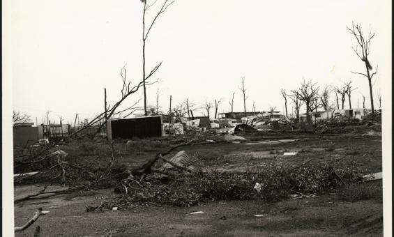
Alan Dwyer, Caravan park in Darwin after Cyclone Tracy, December, 1974, nla.gov.au/nla.obj-148903604

Commemorating Cyclone Tracy through images and oral histories

Fifty years on, see how the destruction and impact of Cyclone Tracy in Darwin 1974 is captured in our collection. 

Blog
Broadside with text reading 'New Colony of South Australia. A Bill having been brought into Parliament under the Sanction of His Majesty's Government for funding a Colony of South Australia. A public meeting will be held in the Great Room at Exeter Hall strand, on Monday next'

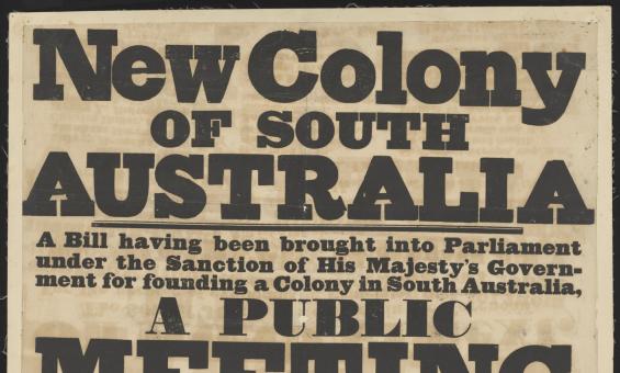
South Australian Association, issuing body, New colony of South Australia : a bill having been brought into parliament under the sanction of His Majesty's government for founding a colony in South Australia, 1834, nla.gov.au/nla.obj-3461873066

Rare broadsides announcing the formation of South Australia

Learn about two broadsides recently added to our collection. 

News article
A black and white drawing depicting a very large crowed of people inside an ornate building watching a parade of people and flags entering the building.

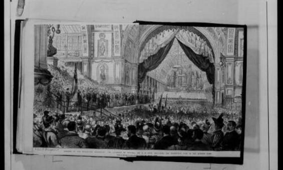
Papers of Sir Anthony Musgrave, Microform, nla.gov.au/nla.obj-1126183854

Federation of Australia

A comprehensive collection of original records of the Federation movement plus books, pictures, music and other material related to Federation.

Collection guide
Topographic map of Gordonvale, Queensland, showing contour lines, roads, rivers, and coastal areas, with military notations from 1942.

Australia. Army. Topographical Survey Company, 2/1st & Australia. Army. Topographical Survey Company, 6th & Australia. Army. Royal Australian Survey Corps. Gordonvale, Queensland Topographical Survey Company, 1942, nla.gov.au/nla.obj-234344829

Australian topographic maps research guide

We hold 200,000+ Australian topographic maps from 1900 onward. This guide helps you find current and historical maps at various scales in our collection.

Research guide
Aerial view of Canberra’s Civic Centre in 1978, showing central roundabouts, surrounding buildings, and Lake Burley Griffin at the bottom edge.

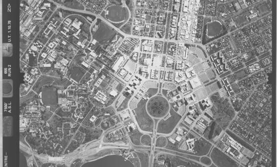
ACT town centre - Belconnen, Woden, Civic, 1978, nla.gov.au/nla.obj-2455089225

Aerial photography research guide

Use this guide to help find and access our series of aerial photographs of Australian states and territories, collected between 1928 and 1988.

Research guide
A bold poster with stacked red text in different fonts reads: COMMONWEALTH OF AUSTRALIA, REFERENDUM, 1916 (MILITARY SERVICE), POLLING: SATURDAY, 28th October, 1916, Commonwealth Electoral Rolls close Monday, 18th Sept., 1916  ARE YOU CORRECTLY ENROLLED for the Electoral Subdivision for which you are entitled to be enrolled? Qualified persons who fail to enrol are liable to a PENALTY OF TWO POUNDS. J. G. McLAREN, Commonwealth Electoral Officer for the State of New South Wales. Sydney, 5th September, 1916.

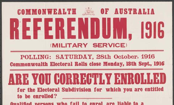
McLaren, J. G and Commonwealth Electoral Office (Australia) issuing body, Referendum, 1916 (military service) : are you correctly enrolled for the electoral subdivision for which you are entitled to be enrolled? Sydney, 1916, nla.gov.au/nla.obj-348412875

Electoral rolls research guide

Find out how to use electoral rolls to locate your family members or other peoples location or addresses over the years and who was living with them.

Research guide
Collection guide
Johnston Collection

Over 13,000 negatives, transparencies, and photographs of cattle stations taken between 1951 and 1961, as well as 52 British Hydrographic Office charts and maps of Australia and the Pacific and personal papers of Johnston.

Collection guide
Collection guide
Plane Table Surveys Collection

182 original field sheets, representing 32 map sheets, dating from 1915 to 1936 including surveys carried out in Queensland, New South Wales, Victoria and Western Australia.

Collection guide

Need help?

Our librarians are here to guide you.

Ask a librarian