The Colonies
The arrival of the First Fleet
The arrival of the First Fleet on Gadigal Country at Sydney Cove in 1788 brought around 1,400 convicts, sailors, soldiers and administrators to Australia.
Over the next 100 years the British occupied more land, establishing settlements and dispossessing First Nations people. What started as a series of precarious British outposts eventually grew to become 6 self-governing colonies, which claimed the entire continent and Tasmania. These colonies competed for migrants from across the British Empire.
Migrants also came from Europe, the United States, China, South Asia and the Pacific. By the 1880s Australia’s population exceeded 2.25 million people. Over the same period, it is estimated that the Indigenous population fell from approximately 750,000 to less than 200,000.
Map of the Port Jackson settlement
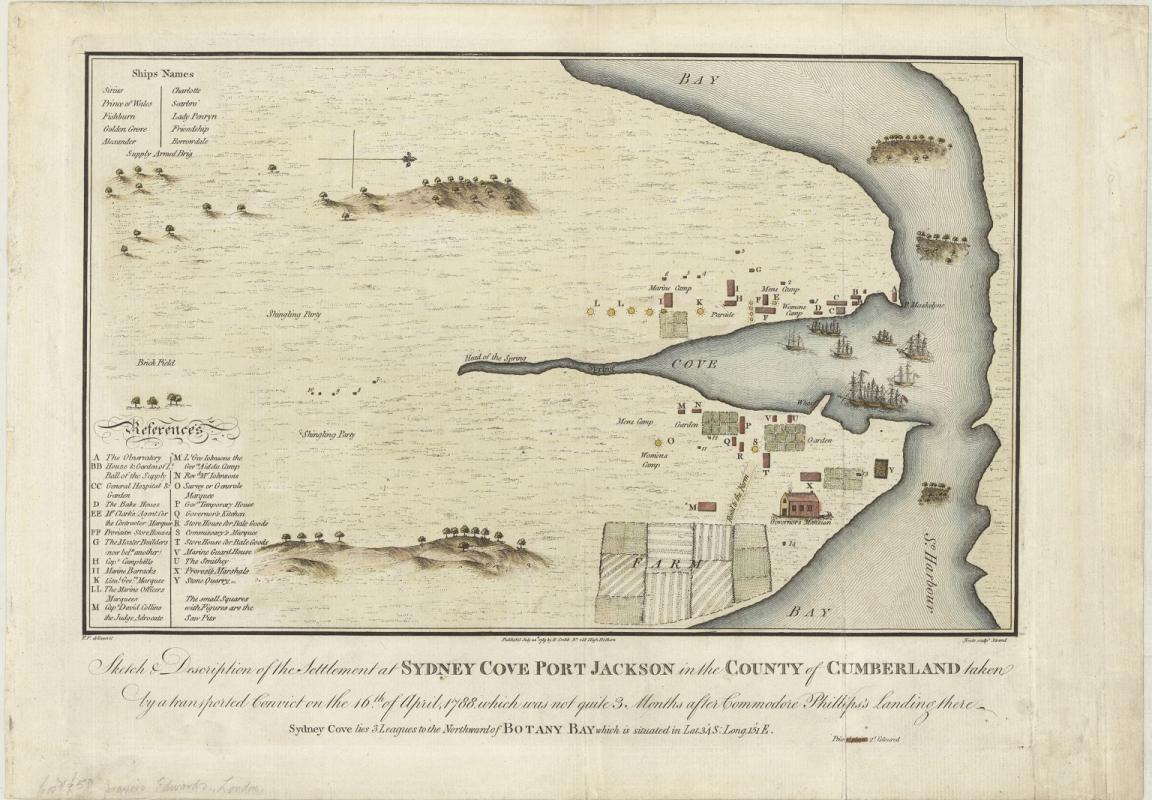
Francis Fowkes, Sydney Cove, Port Jackson, in the County of Cumberland, 1789, nla.gov.au/nla.obj-230578175
Francis Fowkes, Sydney Cove, Port Jackson, in the County of Cumberland, 1789, nla.gov.au/nla.obj-230578175
This sketch, attributed to Francis Fowkes, a former navy midshipman transported for seven years for theft, was the first published map of the settlement at Port Jackson. The site was inhabited by the Gadigal, Cammeraygal and Wangal peoples of the Eora Nation, who did not cede sovereignty for this settlement. The 11 ships of the First Fleet can be seen in the harbour.
The first convicts, sailors and soldiers who came to Australia had little choice in the matter. Many convicts eventually made the transition from prisoner of the Crown to landowning settler or entrepreneur.
Activity 1: Analysing maps
Show the students Francis Fowkes’ sketch and ask them:
- How do you think Fowkes was able to map out the cove without a camera or drone?
- Why would Francis sketch a map?
- What does the sketch tell us about the land in the late 1700s?
- What is missing from the map?
British settlements expand
The growing markets for wool and meat in the 1820s saw an increasing demand for land by migrants, emancipated convicts and native-born settlers.
Some pastoralists occupied land to run sheep and cattle without the approval of either the colonial government or the land’s Traditional Owners. ‘Squatting’, as it was known, remained a feature of colonial life until the 1860s.
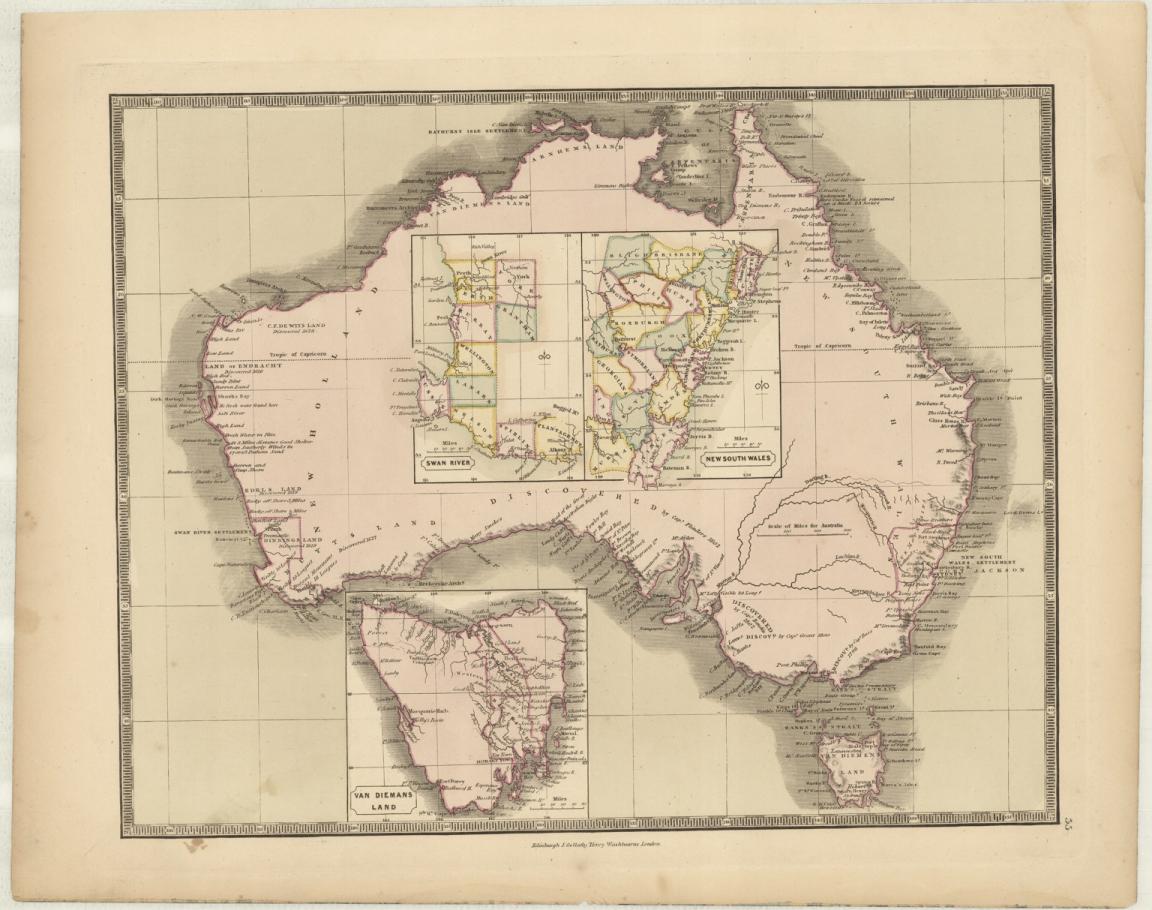
John Gellatly, Map of Australia, with inset maps of the British settlements of New South Wales, Van Diemen’s Land, and Swan, nla.gov.au/nla.obj-3028382243
John Gellatly, Map of Australia, with inset maps of the British settlements of New South Wales, Van Diemen’s Land, and Swan, nla.gov.au/nla.obj-3028382243
John Gellatly’s map from 1843 shows counties, description of topography and dates of discovery. Note the counties of New South Wales shown are the Nineteen Counties which were set as the limits of settlement in the Colony of New South Wales in 1826. Settlers were only permitted to take up land within this defined area.
Activity 2: Change over time
Open John Gellatly’s map in Trove with the students and use the zoom in function to explore the details. Consider the following questions as a class:
- Are there places in the 1800s which now have different names in the 2000s?
- Why might names of places change over time?
- The majority of the 1800s counties are along the coastline. What might be the reason for this?
- Compare the map to the 1996 AIATSIS Map of Indigenous Australia. What are some major differences?
Activity 3: Draft a map
Ask the students to draft their own map of a new island they plan to migrate to. Students should consider the following:
- What does the island already provide?
- What needs to be brought to the island for survival and comfort?
- Where would be the best place to build a house on the island?
Students should draw a final version of the map on A3 paper and include a scale and key.
More to explore
Kathy Weeden reading her book Phonobet, illustrated by Kim Drane and published by NLA Publishing, at Enlighten at the Library 2024
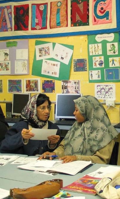
June Orford, Class members, refugees from Afghanistan, Pakistan and the former Yugoslavia, practise English language exercises at the Fitzroy Learning Network, Fitzroy, Victoria, 2005, nla.gov.au/nla.obj-137095404